


Using Surfaces with Forest Pack Pro
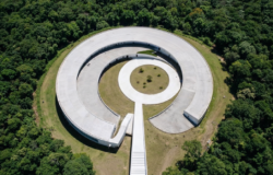
Following the warm reception of the RailClone Tips & Tricks tutorials among users, iToo Software launches a similar initiative for Forest Pack Pro. In the first episode they examine the foundation skills needed for using surfaces, including using camera clipping to cover huge areas with scattered objects and the various falloff controls that allow you to control the density and scale of scattered objects based on altitude and surface angle.

In this Tips & Tricks tutorial for Forest Pack we look at the many options for scattering objects on uneven terrain. It’s not often the case that we place scattered objects on a truly planar surface, instead in many scenes we have banks, mounds, hills, and even vertiginous mountains. Forest Pack not only allows you to place geometry on non-planar surface with a minimum of effort, but also gives you a high level of control, with the ability to control the density and scale of the scattered objects based on the altitude and slope angle of the terrain.

Check out the Using Surfaces tutorial now!
The files that come with this series are compatible with 3ds Max 2011 2015, and Forest Pack Pro.
Make sure you check the readme file that comes with this scene for the terms of use


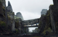
Where did they take such a good terrain model with the texture all together?
luckyfox777 The terrain data comes from DEM files freely downloadable from https://www.usgs.gov/pubprod/ . These were then stitched together and then used with a displace modifier to create the landscape with corresponding satellite images (also available from USGS) to create the textures.
All the tips and tricks tutorials can be found here: https://www.itoosoft.com/tutorials.php. Just to clarify, they are not made by users, but appreciated by them 😉
Lonelymonk
Thank you, Paul. I thought some plugin was used. Now it’s clear.
Since you are reading and it was suggested that we can add ideas for future tips and tricks videos.
I was curious if there is a way one could create fruits and vegetables with FP, I mean the ones that have repetition and variation or small “components” in them. i.e. Corn, Raspberry, lemon/orange, strawberry, etc.
luckyfox777 That’s a great idea for a tutorial, I’ll add it to the wishlist. XOIO used Forest Pack for just that purpose, you can see an example in our gallery : https://www.itoosoft.com/gallery/detail.php?idimg=berlin_flat .
Lonelymonk
And since I got your attention, Paul, I would also request/suggest some tutorial on stitching, maybe it’s more of RC topic, but I mean various types of stitching or maybe some advanced and intricate types as well.
What is commonly used now are various methods but none of them in my opinion is at the same time elegant and easy to adjust, edit afterwards, customize, enhance. Which could be a point where FP or RC of Itoo software house could sparkle.
For example I use standard spacing tool in 3ds max, which sometimes doesn’t give the desired results when the spline path has various curvature and couple direction changes in the way.
Cheers.
Hi Paul
what I like to see is a tutorial for making hedges (cut and uncut hedges, different sort of hedges, maybe even different heights, …..)
thanks
Thanks for all the suggestions. Keep them coming 🙂
I have a few questions Lonelymonk regarding the terrain and the displacement map.
A) Where exactly do I go at https://www.usgs.gov/pubprod/ to download the DEM images? There are so many links to that site and it’s confusing the hell out of me.
B) How exactly were you able to displace the DEM map in 3ds max if you’re using the same color image? I’m familiar with with the displacement modifier but I’ve only used black and white terrain maps, so I’m assuming that’s what you did correct? Did you convert that jpeg map in Photoshop into a a black and white image or are those files already located in the usgs site and I’m not aware of it?
Thanks for your help.
iamtheski Lonelymonk Hi, yeah that site is a bit of a part of a maze. The part you’re after is https://nationalmap.gov/viewer.html , from here you can download separate elevation data (essentially a greyscale height map) and seperate ortho imagery (colour data). However it is usually split into a number of tiles and will need to be reassembled. You might find this tutorial set by Gnomon workshop useful for learning more about this workflow: https://www.thegnomonworkshop.com/store/category/5/ . The 3D part is in Maya but it’s easy enough to translate to Max.
Cheers,
Paul
Thank you, Paul, for the hint. And good luck next week at SOA D5.
wish I could come…, I enjoyed and learned a lot from your presentation past year.
Cheers.